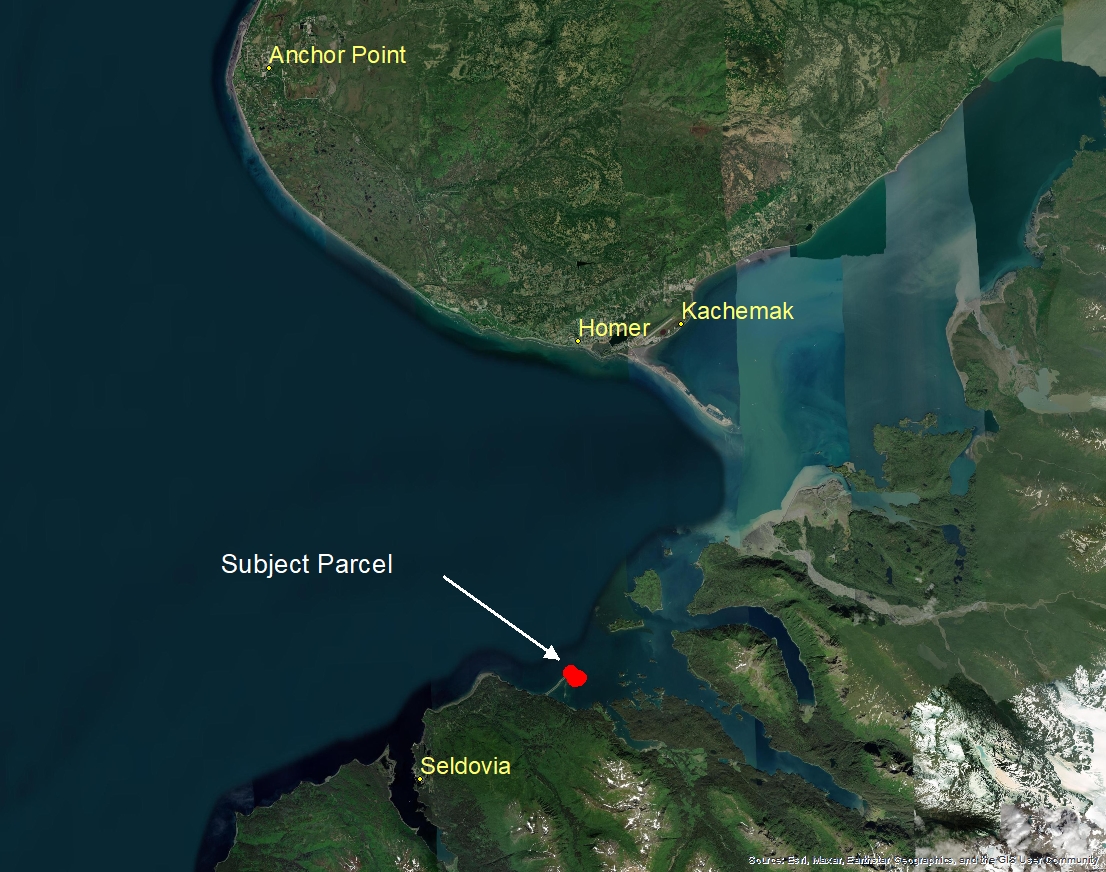
MacDonald Spit, Seldovia
Location
Seldovia is on the Kenai Peninsula on the south shore of Kachemak Bay, and falls within the gulf coast maritime climate zone, characterized by a rainy atmosphere, long, cold winters, and mild summers.
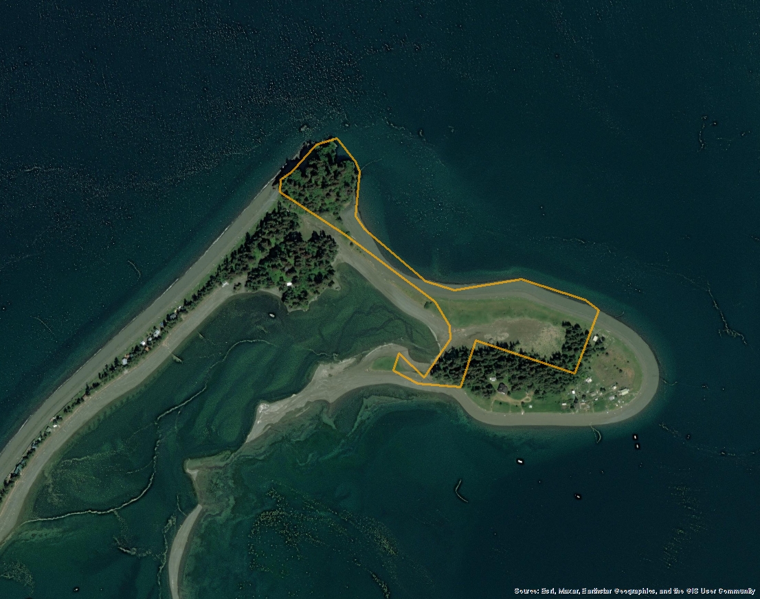
Parcel 9200843
- 16.34 acres
- Mental Health Trust Parcel Number: SM-0415
- Kenai Peninsula Borough Tax ID: 19110114
- Located in Section 18, Township 5 North, Range 8 West, Seward Meridian, Alaska
- Survey: Lot 10 of U.S. Survey 4651
- Minimum Annual Rent Bid: $47,500.00
Access
A state-owned gravel airstrip and a seaplane base are available. Direct flights are provided to Homer. The state ferry system connects to Homer, where the Sterling Highway provides road access. Water taxis from Homer also service the community. A harbor, boat wash down, and boat haul-out facility are available.
Primary access is by boat or floatplane. Access is also available from Jackalof Bay Road to a pedestrian/ATV easement along the MacDonald Spit beach.
View
Easements
Water Frontage & Shape
The boundary adjacent to Kachemak Bay has approximately ±2,300 LF (unprotected) water front. The parcel boundary adjacent to the Kasitsna Bay Lagoon has approximately ±1,400 LF (protected but tidal influenced).
The parcel is an irregularly shaped lot with a high amount water frontage. Given the size and shape it may be well suited for further subdivision.
Improvements or Trespass
Public Restrictions
The parcel is located within the boundaries of the Kenai Peninsula Borough (KPB) but outside any city limits; the area is un-zoned.
Environmental Restrictions
Conservation Restrictions
The Kachemak Bay State Park, Kenai National Wildlife Refuge and the Kenai Fjords National Park are all located within or near Kachemak Bay. The subject does not appear to be located within any of these units.
McDonald Spit is located within the Kachemak Bay — Critical Habitat Area
Easy access, outstanding recreational opportunities, and a diverse and productive environment make Kachemak Bay important to residents and visitors alike. Fish and shellfish populations abound year-round, supporting several significant fisheries. In the spring, summer, and fall, the bay hosts tens of thousands of feeding waterfowl, shorebirds, and seabirds. In the winter, marine mammals and waterbirds remain in the bay's protected waters.
The high level of biological productivity in Kachemak Bay is at least partially the result of a large gyre-like circulation pattern that serves to hold shellfish larvae in the bay. Productivity is further enhanced by a two-layered "nutrient trap" estuarine system in which organic nutrients are moved out of the bay by surface waters and settle to the bottom only to be moved back into the bay by deeper on-shore currents.
For more information on the Kachemak Bay Critical Habitat Area please refer to the Kachemak Bay Management Plan. For current land status information, see the Kachemak Bay Land Status Map (PDF 2,058 kB). You may also download the KML file which depicts the refuge area boundary.
Private Restrictions
There does not appear to be any private restrictions.
Other Restrictions
Utilities
Topography
Much of the parcel's acreage consists of beach and low-lying grasslands that are susceptible to high-tides and waves.
The parcel is ocean fronting with a good beach and is primarily level at the middle and eastern end, and slopes upward on the west side at Nubble Point. Spruce trees are located on the east and west sides of the lot. The parcel appears to have a suitable buildable site on the west side. Possible building locations may be located on the east side; however, the east side appears to be susceptible to periodic tidal surges.
Hydrology
Soils
According to the National Wetlands Inventory, the subject does not have any areas of wetlands.
This area is part of the Chugach Terrane, a complex of Mesozoic strata, including sedimentary sandstone, radiolarian chert, and mafic pluton.
Soils appear adequate for improvements.
Vegetation
Flood Plain
Seismic
Environmental Issues
Suitability
Notes
Maps & Survey
- USS 4651
Note: Maps included are for graphic representation only and are intended to be used as a guide. It is the responsibility of the purchaser to review recorded subdivision plats/maps, surveys, and plat notes for specific information on easements, building setbacks, or other restrictions that will affect any individual parcel. Information is made available at the Department of Natural Resources Public Information Centers or on the web at: http://dnr.alaska.gov/landrecords/