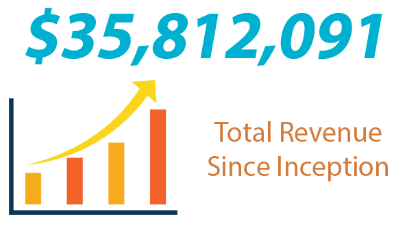
Minerals & Materials
Current Lease Opportunities
Most of the mineral assets managed by the Trust Land Office are located in the Interior and Southeast Alaska. Prospective mineral tracts are typically offered for exploration and development through a competitive leasing process. While many State of Alaska mining claims exist on Trust land, new mining claim staking is not allowed. Instead, Trust minerals, like other Trust resources, are disposed of on a competitive basis.
The Trust Land Office also sells material including sand, gravel and rock resources. A very simple and straight forward process allows for the sale of a minimum of 3,000 cubic yards up to 100,000 cubic yards of material. The sale of volumes larger than 100,000 cubic yards is by a competitive bid process only.
For more information, please contact:
Dr. Karsten Eden
Chief Geologist
Phone: (907) 269-8656
karsten.eden@alaska.gov
Icy Cape
The Trust Land Office conducted further exploration work on its Icy Cape property. The Icy Cape Gold and Industrial Heavy Minerals Project is designed as a staged and incremental effort with its focus on evaluation of the potential for development of gold and industrial heavy mineral resources. The elevated marine sand deposits contain garnet and epidote group minerals, rutile and zircon, as well as gold and platinum placers.

Salcha Block
The Salcha land block, owned by the Alaska Mental Health Trust Authority (Trust) and managed by the Trust Land Office (TLO), contains approximately 180,000 acres of land in the Fairbanks Mining District that is available for minerals exploration and development. The Salcha Block is located in the prolific Tintina Gold Province in the interior of Alaska. The center of the land block is approximately 45 miles east southeast of the Fort Knox gold mine (Kinross) and approximately 30 miles northwest of the Pogo gold mine (Sumitomo).
The Salcha Block lies within the Yukon-Tanana-Terrane (YTT), a highly deformed belt of Precambrian to Paleozoic quartz-feldspar mica schists, gneiss, limestone and black shale. The Block is intruded by Cretaceous to Tertiary granite, quartz monzonite, and granodiorite plutons (K-Ar age + 106 – 111 Ma).
Between 1996 and 2011, Kennecott Exploration, Newmont, NovaGold, Barrick Gold, AngloGold Ashanti, International Tower Hill and Kinross conducted reconnaissance and advanced reconnaissance exploration programs on the Block, primarily for intrusive-related gold. The primarily exploration focus was on the Radio and Caribou prospects, but other significant discoveries have also been made by those companies that warrant further investigation.
The Salcha Block represents a prime exploration target for intrusion-related gold deposits. Exploration to date by various junior exploration and major mining companies have delineated highly mineralized zones that warrant further investigation to determine if an economic near-surface deposit of sufficient grade is present on the Salcha Block.
The Trust Land Office has developed a comprehensive GIS database for the Salcha Block comprised of geological, structural geological, geochemical and geophysical datasets that allows for quick access and easy comparison of complex datasets, and aids the stimulation of mineral exploration concepts. Data may be viewed at the Trust Land Office offices after signing a confidentiality agreement.
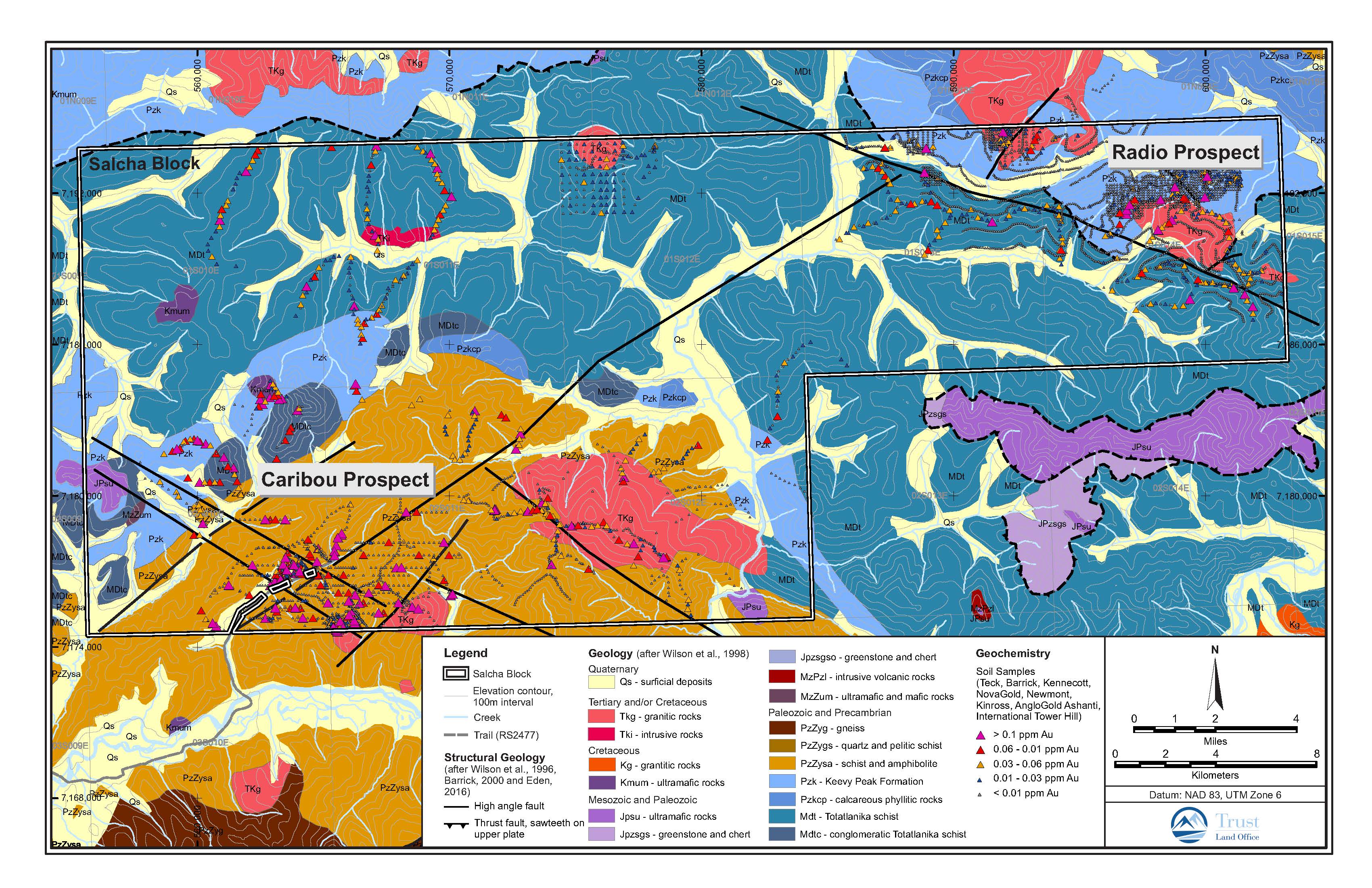
Salcha Map
Liberty Bell Block
The Liberty Bell land block, owned by the Alaska Mental Health Trust Authority (Trust) and managed by the Trust Land Office (TLO), contains approximately 36,000 acres of land in the Bonnifield Mining District that is available for minerals exploration and development. The Liberty Bell Block is located in the prolific Tintina Gold Province in the interior of Alaska. The center of the land block is approximately 20 miles northeast of Healy and approximately 55 miles southwest of Fairbanks. The property has excellent access and infrastructure; it is in close proximity to the George Parks Highway.
Much of the geologic terrane is underlain by Devonian-Mississippian Totatlanika Schist and unconformably overlain by Tertiary coal-bearing units and the Nenana Gravel. The Paleozoic rocks consist of metamorphosed clastic sedimentary units and a small volume of metavolcanic units including metarhyolite and metagabbro; these units are also intruded by similar aged granite. Cretaceous (92 Ma) granite to granodiorite intrude the Paleozoic rocks. Structurally the area is dominated by northeast and east-west trending faults sub-parallel to the Denali fault system.
Regional metallogenesis indicates that several styles and ages of mineralization are present in the district. This includes Paleozoic volcanogenic massive sulfide deposits (Kuroko-type), Cretaceous intrusion-related gold systems, Cretaceous intrusive related skarns, replacements, and veins, as well as the Quaternary placer gold deposits variously associated with scheelite, platinum group metals, and wolframite.
The Liberty Bell Block represents a prime exploration target for intrusion-related gold deposits. There is a trend of intrusive dikes and stocks of granite-granodiorite extending easterly from the adjacent historic Liberty Bell Mine area across the southern portion of land on the Liberty Bell Block that has excellent exploration potential. Exploration for copper-gold porphyry and associated gold deposits is currently carried out in the vicinity of the historic Liberty Bell Mine by a Junior company/Major Mining company Joint Venture.
The Trust Land Office has developed a comprehensive GIS database for the Liberty Bell Block comprised of geological, structural geological, geochemical and geophysical datasets that allows for quick access and easy comparison of complex datasets, and aids the stimulation of mineral exploration concepts. Data may be viewed at the Trust Land Office offices after signing a confidentiality agreement.
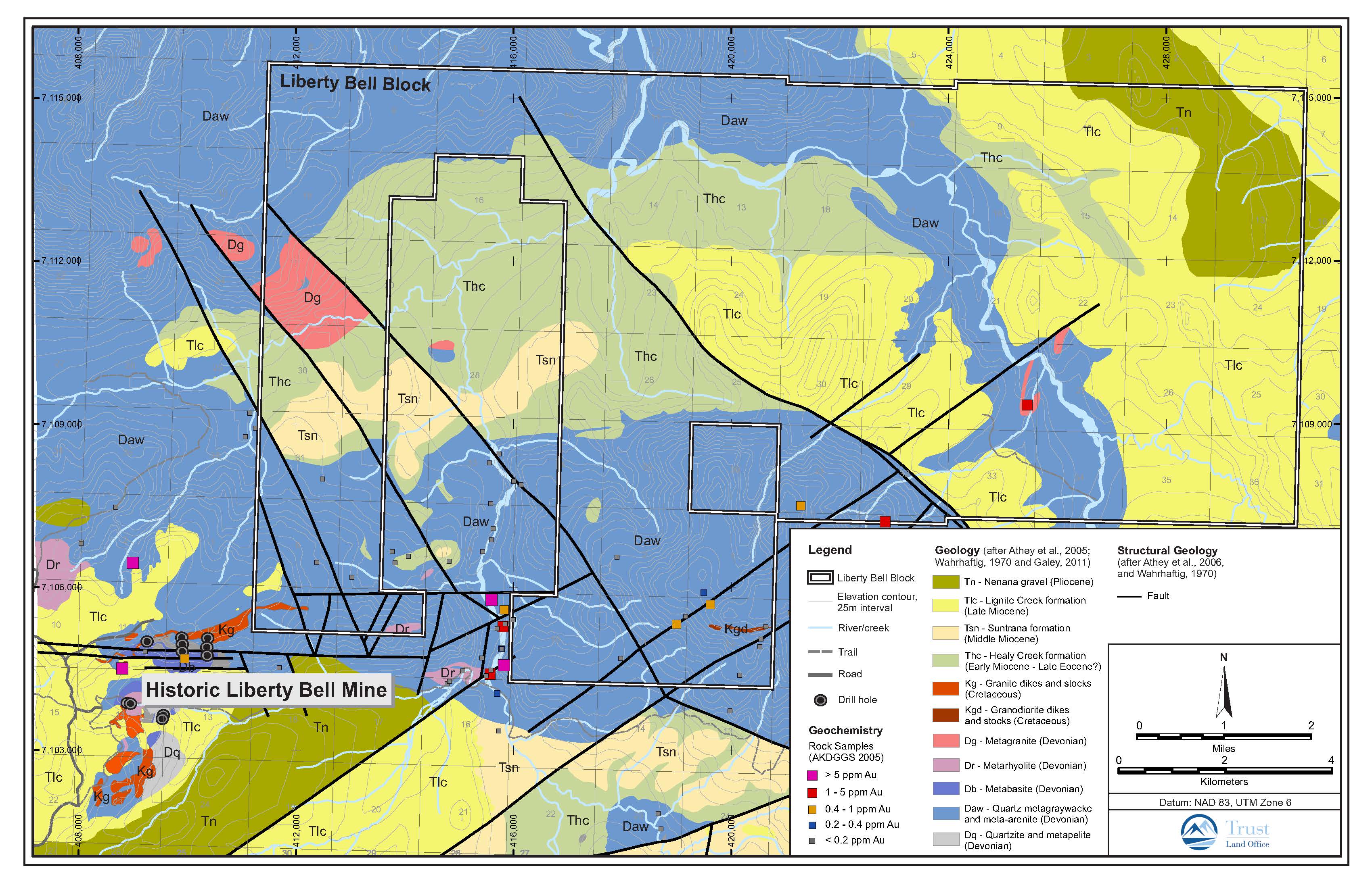
Liberty Bell Map
Ophir Block
The Ophir land block, owned by the Alaska Mental Health Trust Authority (Trust) and managed by the Trust Land Office (TLO), contains approximately 13,300 acres of land in the Innoko Mining District that is available for minerals exploration and development. The Ophir Block is located in the prolific Tintina Gold Province in the interior of Alaska approximately 36 miles west northwest of McGrath and south of the Innoko River.
The Ophir-Tolstoi-Innoko area has produced more than 500,000 ounces of placer gold since gold was discovered in the late 1800s. The placer gold deposits in the district are spatially related to porphyritic intrusive dikes and sills. Most auriferous hard rock occurrences discovered to date in the Ophir Block consist of quartz veins and veinlets with various combinations of arsenopyrite, stibnite and other sulfide minerals. These associations are similar to intrusive-related gold mineralization elsewhere in the Tintina Gold Province. However, the prospect geology, age of intrusive rocks, and geologic setting at Ophir is most similar in many respects to the Donlin Creek gold deposit; restoration of movement on the Iditarod Nixon Fork Fault indicates the Ophir Block and Donlin were near neighbors 70 million years ago near the time of deposit formation.
The Ophir Block represents a prime exploration target for intrusion-related gold deposits. Exploration to date by USMX and Kinross Gold has delineated highly mineralized zones that warrant further investigation to determine if an economic near-surface deposit of sufficient grade is present on the Ophir Block.
The Trust Land Office has developed a comprehensive GIS database for the Ophir Block comprised of geological, structural geological, geochemical and geophysical datasets that allows for quick access and easy comparison of complex datasets, and aids the stimulation of mineral exploration concepts. Data may be viewed at the Trust Land Office offices after signing a confidentiality agreement.

Ophir Map
Thorne Bay Block
The Thorne Bay land block, owned by the Alaska Mental Health Trust Authority (Trust) and managed by the Trust Land Office (TLO), contains approximately 4,700 acres of land in the Ketchikan Mining District that is available for minerals exploration and development.
The Thorne Bay block is located on the Kasaan Peninsula, Prince of Wales Island, directly south of Thorne Bay, Alaska. Access to the property is from all-weather roads from either Hollis or Thorne Bay. The timber has been clear cut, and an extensive road system provides good access with numerous borrow sites and road cuts to aid in mineral exploration and geological and structural field mapping.
The Kasaan Peninsula is composed largely of Devonian, and Silurian to Lower Ordovician, lower greenschist facies metamorphosed submarine andesitic tuffs, breccias and flows and andesitic volcanic greywacke and conglomeratic volcanic greywacke, inter-layered with marble and limestone, mud, sandstone and clastic rocks. These country rocks have been faulted, folded and intruded by numerous dikes, sills and stocks, including gabbro, pyroxenite, pyroxene diorite, diorite, quartz diorite, quartz diorite porphyry, granodiorite, monzonite, diorite porphyry, diabase and basalt.
Copper ore was discovered on the Kasaan Peninsula by the Russians in 1865, and the first lode claims in Alaska were reportedly staked in 1867. The property hosts several historic copper mines including the Haida Mine. Most of the production and development occurred from about 1900 to 1918.
Recent exploration and research classify the copper and iron mineralization on the Kasaan Peninsula as iron oxide-copper-gold (IOCG) type mineralization with ores consisting of magnetite, pyrite and chalcopyrite with pyrrhotite and trace amounts of electrum, sphalerite, native bismuth and hematite.
The Thorne Bay Block represents excellent exploration potential for iron, copper and gold of the IOCG type. Recent exploration success by a junior exploration company on land in close proximity to the Block helps support this.
The Trust Land Office has developed a GIS database for the Thorne Bay Block comprised of geological, structural geological, geochemical and geophysical datasets that allows for quick access and easy comparison of complex datasets, and aids the stimulation of mineral exploration concepts. Data may be viewed at the Trust Land Office offices after signing a confidentiality agreement.
