OTC: Highbush Lane
Location
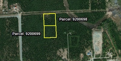
Parcel 9200698
- TLO (MHT)# 9200698
- 2.50 Acres
- Legal: S6N11W34
- Survey: USRS S006N011W34
- Lot 4
- Purchase Price: $22,500.00
Parcel 9200699
- TLO (MHT)# 9200699
- 2.5 Acres
- Legal: S6N11W34
- Survey: USRS S006N011W34
- Lot 5
- Purchase Price: $21,000.00
Access
Pearson Avenue, a paved street, ends approximately 600 feet to the west of MHT 9200698. A section line is along the northern boundary, along with a utility easement, of MHT 9200698. MHT 9200699 may be accessed through MHT 9200698, if concurrently owned, or an easement through an adjacent parcel owned by the Alaska Mental Health Trust Authority may be purchased for access from Highbush Lane or the section line to the north.
The parcel is located within the Kenai Peninsula Borough and is subject to real property taxation.
Utilities
Electricity, natural gas, and telephone are available in the area. Potential purchasers should contact Homer Electric Association for costs and more information on electrical power to the parcels, as well as, Enstar for natural gas service.
There is no central public water and sewer in the area. Water is typically handled by a private well and sewer is typically handled by a private septic system which would have to conform to Alaska Department of Environmental Conservation requirements.
Notes
The parcel is mostly level and densely wooded.
Maps & Survey
Note: Maps included are for graphic representation only and are intended to be used as a guide. It is the responsibility of the purchaser to review recorded subdivision plats/maps, surveys, and plat notes for specific information on easements, building setbacks, or other restrictions that will affect any individual parcel. Information is made available at the Department of Natural Resources Public Information Centers or on the web at: http://dnr.alaska.gov/landrecords/